The Power of 7

Rome has its hills, of course, as does Lisbon. Snow White had her dwarves, Eddie Foy, his little ones. The man from St. Ives had his wives, as did the brothers. Shakespeare had his ages; T. H. Lawrence, his pillars of wisdom, and William Empson, his ambiguities. Satan had his sins and Christ, his works of mercy. Secaucus had its returnees.

Sao Miguel has Sete Cidades–Seven Cities, though on my several visits, I’ve only been able to find one small town.

The area is the most stunning space on this island, a place that I cannot help returning to. After this trip, I can now say it’s the most stunning space in the southeastern islands of the archipelago. During our few days on Santa Maria, Nancy and I discussed the logisitics of visiting the remaining 7 islands. All of those 7 would be new to me; Nancy had previously visited some of the central islands: Faial, Terceira, and Pico.

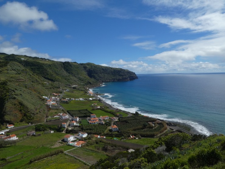
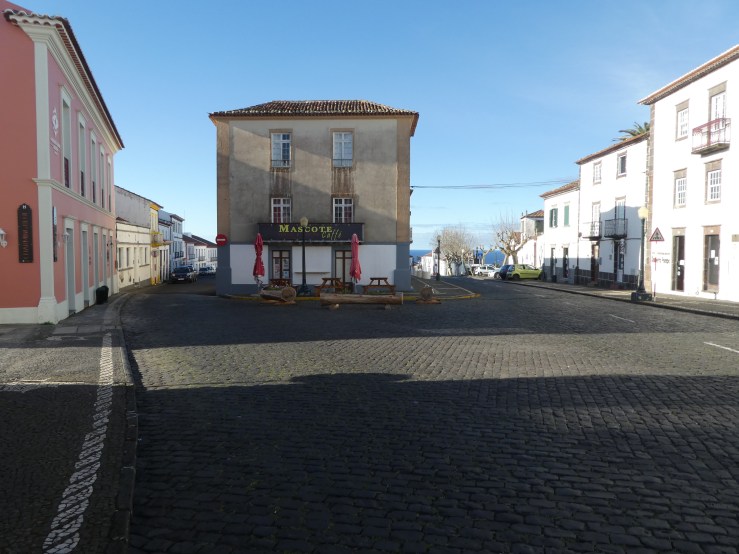
A few years ago I reported on a visit to Sete Cidades, wondering why a rural community would have such a grand title. The town does has an elegant church on a central square, the usual basalt blocks framing a tidy and symmetrical building, with white plaster covering the stone walls. The round cupola makes a distinguishing feature since many other churches rely on square bell towers.

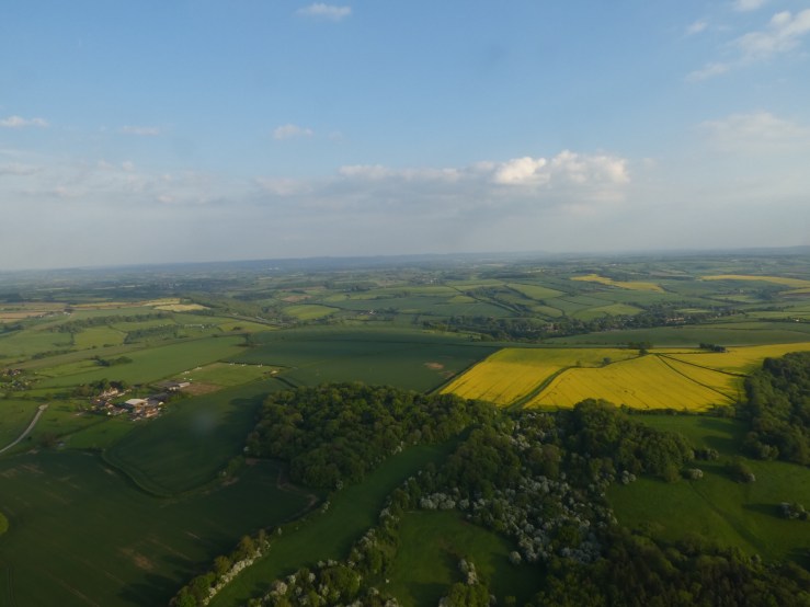
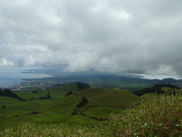
Sete Cidades has settled in an extinct volcanic crater, and its grandest feature is really the view from the rim of the crater several hundred feet above the town.

Here’s a 30 second video that sweeps across the two lakes that fill in the crater.

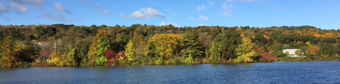
The drive from the port of Ponta Delgada heads into steep hills that dominate the western part of the island. Near the summit narrow roads skirt the crater rim and provide views inward toward the crater and outward to the rich, green Azorean countryside. And since the island is narrow–only about a12 kilometers at the center–a view from the top provides a glimpse across the waist of both the northern and southern Atlantic coasts.

The drive to Sete Cidades turned problematic on this trip because we wandered into the Azores Rallye, a multi-stage race, part of a European road-rallye competition in which competitors race modified cars along public roads. Earlier, I had walked around a city square where many (all?) cars waited for the official race.

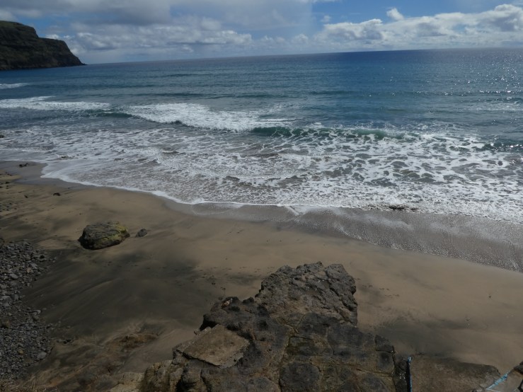
On our ride out several cars cars sped past us climbing to the crater rim, negotiating tight curves with more confidence and expertise than I have. Along the route, much more heavily trafficked than usual, clusters of fans gathered waiting for the race to begin, ready to watch for their favorite drivers or cars, recognizable, I assume, by the gaudy vehicle decorations. I felt sufficiently disgruntled at this frivolous intrusion into what I’ve come to imagine as a pristine landscape. The area is ecological fragile, and the government accords it a protected status. The lakes are kept pristine by controlling development and farming practices and by keeping motor craft off the waters. More environmentally sensible water craft are allowed–unless there’s an underground passage from the U.S. ocean archipelago in the Pacific.

The Raylee disrupted our day by closing one of major roads leaving Sete Cidades and all Nancy and I could do was retrace the route out of the crater and back to Ponta Delgada.

Garden Plot

In the last quarter of the 18th century, after working several years in the Caribbean, Thomas Hickling, a Boston business man, somehow ended up San Miguel, Azores. He had left his wife and family back in Boston, never to go back to his family and home (and did he ever return, no he never returned), but he used his business skills to ply his merchant trade in Ponta Delgada, becoming known as the “honorary consul” to the Azores. Later in the 1790s, just after the founding of the United States, Hackling managed to get himself appointed officially as Vice-Consul and served that role for many years. The U.S. consulate in the Azores remains the oldest diplomatic office of the U.S.

Living in Ponta Delgada Hackling made a fortune in the Azorean orange industry which exported a substantial crop each year to Great Britain, until the groves were destroyed by a disease in the mid-19th century. Early in his residence on the island he learned about the thermal springs in Furnas, where he purchased some land, built a summer house called “Yankee Hill” (even though he had effectively abandoned Boston and its environs, he clearly wanted to his identity), and constructed a thermal pool so that he too could take the waters.

And he built a garden. Initially he brought in several alien species, trees from the U.S. to decorate the landscape. By the end of the 19th-century, Hackling’s home had long been sold off, Yankee Hill replaced with a more Portuguese-styled estate, but the garden grew. In the early 1930s a group of local developers, led by Vasco Bensaude, organized the building of a modern hotel and casino on this site, dramatically encouraging tourism in Furnas.

The hot springs were an obvious attraction, but the developers re-organized the layout of a formal garden on the grounds of the Terra Nostra Hotel as a further attraction.

The Terra Nostra Garden evolved gradually into a UNESCO World Heritage Site. Bensaude’s Scottish gardener took the mild Azorean climate into account to arrange the plantings in the garden today. Warmed by the Gulf Stream, with annual temperatures varying between 55 and 75 degrees F, the islands can support flora more exotic than North American imports. The Garden is now dominated by trees and plants from China, Japan, Australia, and South Africa. The riotous merging of ferns and fronds creates jungle-like landscape.

So jungle-like, in fact, that someone on the Garden staff has developed topiary techniques to play on the impression of a Jurassic landscape.

The center piece of the Garden remains the thermal bath where water emerges at 95-105 degrees F to fill a four-foot deep pool. The high iron content of the water oxidizes as it hits the air, giving the water a brown tint. Rumors suggest that the water will turn blonde and white hair orange, but so far we’ve only managed to stain the robes and towels supplied by the hotel.

On our first visit to the Azores in 2011, Nancy and I arrived mid-spring and were welcomed by an outburst of hydrangeas which flourish in many colors because of the acidic soil. Our recent trips have preceded those blossomings, but late winter on Sao Miguel offers astounding camellias–the Garden’s collection has over 800 varieties–and azaleas–often along any sidewalk.

Unfortunately, with such excessive flowering, someone has to tidy up the mess.

Santa Maria Coast Line

Islands set limits on movement; one can only go so far before turning back to the beginning—or one can circle endlessly. A small island emphasizes how little choice one has on where to go.  In four days on Santa Maria, Nancy and I have driven along every major highway. The secondary roads are quite often daunting, barely wide enough for two cars to scrape by. And I do mean scrape since the roads, lined with stone walls, lack shoulders. Our rental car came with scratches on both right and left wing mirrors. From Vila do Porto on the southwest point, we would head out and invariably encounter a beach, a bay, a coastline. After a short drive, never longer that 10 miles, the ocean always presented itself.

The geological upheaval that thrust the Azores up in the middle of the Atlantic created many islands with hilly or mountainous landscapes. On Santa Maria, dominated by one central mountain we followed roads up and over ridges or along the coast until we reached baias (bays) or praias (beaches). The road to Sao Lourenço on the west coast crosses the shoulders of the central mountain—Pico Alto (about 1800 feet high)—and descends precipitously down a 10% grade into the village, a grade made barely manageable by the constant switch backs. The hillsides, sloping sharply to the edge of the water, leave just enough space for a community to wedge itself onto the shore.
The steep seaside hills require effective erosion control to keep houses from sliding into the bay and protect those along the beach. While this house must offer astounding ocean view, it also requires a taxing climb up the hillside when returning home with bags of groceries. 

But at sea level, the prospect from on the rocky beaches made me ready to entertain the idea of settling in.
Perhaps even join the local swim club.
Joe

Pirates Be There

The characteristics that attracted the early settlers on Santa Maria to the Baia dos Anjos—an anchorage with easy access to the shore for loading and unloading—proved attractive to others sailing the eastern Atlantic sea lanes. Pirates (or corsairs) from the North African states soon made the Azores a regular stop during their predatory wanderings. The Spanish, still not completely reconciled to Portuguese independence, felt the right to stop in on occasion to take advantage of what the locals had to offer. And in the mid-16th century, during the Spanish wars, British privateers, making no distinction between the Iberian states, raided occasionally.

Fearing sporadic attacks, the early Santa Marians decided on another site for their main settlement. On the south coast of the island, they identified a ridge, between two narrow ravines, sweeping down to the ocean, and stopping on a bluff above a bay.  

The bluff was the ideal site for a small fort—Fort Brás—nothing more than a wall mounted with several cannon.

Cannons to the right of me, cannons to the left of me.

The fort offered, however, a commanding view of the bay, and any ships entering were within range of the cannon. While the fort could not defend the town itself, the narrow ravines provided a natural defense. Any pirates, soldiers, or privateers who managed to land would face a challenging, up hill struggle to reach the village, where even a small local militia might ward off any exhausted attackers who reached the top of a ravine.

The village became Vila do Porto the major (and really, the only) city on Santa Maria. The narrow ridge of the city severely constrained development to one main street running due north from Fort Brás and two parallel side streets. The tiny communities scattered over the island are not very far from this local metropolis, but the twisting, narrow roads that wander across the island make for slow, arduous journeys.

The move to Vila do Porto proved successful, somewhat, and militia fought off several attacks throughout the 16th century. Pirates are, however, resourceful, and on several occasions, ships landed attackers further along the coast out of sight. They managed to escape detection, climb the ravines, and assault the local population. To be sure, the island offered little plunder, but slavery was still a flourishing trade, and many Santa Marians were carried back to North Africa and sold.

Today, only seagulls guard the bay.

Santa Maria, Azores

As I probably reported during my previous visit, the Azores were “officially” discovered in the mid-15th century by Portuguese explorers, although Portuguese fishermen most likely were visiting as early as the 1200s. “Discovered” is a correct word in this context since the islands were uninhabited when any wanders ventured ashore. No local population existed for rampaging explorers to kill or enslave. The islands were pristine, ripe for the taking.

Santa Maria is the easternmost/southernmost of the nine-inland archipelago and was the first island settled, around 1450, at the Baia dos Anjos (Bay of Angels).

In 1493, on returning to Spain from his first voyage, Columbus ran into a storm and lost one of his ships. In a fervid moment, he prayed for the return of that ship and promised to have a mass said at the first opportunity to land. Santa Maria (which was not named after one of Columbus’s ships) provided that chance to redeem his promise. Spanish sailors, landing to say mass, were not, however, well received by the local Portuguese. Already subject to raids by pirates and Spaniards, they were not ready to welcome Columbus with his astounding news. One legend suggests that the Spanish ships in the harbor were stoned to encourage them to leave. After some negotiating, the mass got said, the ship got found, and Columbus continued his homeward journey.

Anjos today remembers that visit more fondly and the Azorean government erected a memorial to Columbus in 1993 to commemorate the 500th anniversary of the landing.

Santa Maria is the 3rd smallest of the islands, about 6 miles wide by 11 miles long. In such a confined space, the geography changes constantly. All the islands formed from volcanic eruptions, so the beaches at Anjos are littered with basalt rock formations, as lava cooled on flowing into the ocean. What remain are rocks are much too sharp for sea-side lounging.

The volcanic upthrust of land also created a chain of mountainous hills sweeping down the eastern third of the island. The route from north to south crosses over steep hills into narrow valleys.

.

The road terminates at Praia Formosa, where, at low tide, a more loungeable sandy beach faces the mid-Atlantic.

Wandering Around Oxford.

We are back in London for a few days before our flight leaves for home. Having left the Cotswolds, we first drove to Oxford for a bit of urban action to balance the serenity of the Cotswold countryside. And I must admit, that as with Cambridge, I was looking forward to walking into a university environment. The first stop on our Oxford walk was Blackwells Books, one of the finest bookstores I’ve ever entered. Going there was a frustrating moment for both Nancy and me since we didn’t think we could afford to load up our luggage with more books. Instead, I wandered around with my phone out taking pictures of books I will look into on my return.

Another major stop for our Oxford visit was the Ashmolean Museum.

I had visited the museum on a previous trip over 40 years ago and remembered it as a dingy rambling place. Parts of it have been refurbished and today seems brighter and more open. Instead of investigating the permanent exhibitions, the opted for a special show, “America’s Cool Modernism, O’Keefe to Hopper.” The paintings, etchings, and photographs focused on urban and industrial themes, empty of human characters and filled with flat, stylized cityscapes or abstract, allusive shapes and colors.

But the real goal for any walk through Oxford is visiting the colleges. As in Cambridge, the colleges effectively control access to their quadrangles, chapels, and lawns. They are, after all, working spaces, as we were repeatedly reminded, still in the middle of a term; the students were not to be disturbed. Each college has its own main gate for visitors, while students slip in and out of side doorways. If the college is open, it charges a modest fee for the privilege of getting a glimpse of student life. I was disappointed not to see groups of undergraduates hurrying along with robes flying in the wind. The few students on view looked remarkably like students on the way to classes on the Cornell campus.

Christ Church seemed like a good starting point. I don’t know if it is the largest college but it certainly has the most spacious quadrangle and and a gorgeous Great Hall (its walls completely covered with portraits, not least of which was one of Henry VIII), as well as its own cathedral.

We entered the hall late morning along with a group of German high school students. The tables were already being set up for lunch and later with the doors closed, students would arrive for a mid-day meal.

With too many colleges we could not manage a visit to each, so we simply walked the streets, peeking into the quads as we encountered them, and choose any that looked inviting. While many of the colleges line very busy Oxford streets, Merton College provides a view across a large sports field which was being prepared for some athletic event cricket perhaps.

Around the corner and down the road, at New College, we walked under the Bridge of Sighs, a walkway between college buildings; Cambridge’s Bridge of Sighs actually crosses the Cam.

Among the colleges, Balliol might be the most picturesque, with several courtyards, well-tended gardens, and huge beech trees.

And while students sprawled on the lawn, magpies scrounged the grounds for sustenance.

What Goes Up . . .

So there I was in a hot air balloon gondola floating over the countryside of Bath, with fields of rape seed in stunning yellow in the distance.

The pilot said we were at 1500 feet. Once the ascent had begun, the mood in the gondola turned quite. We could catch odd sounds drifting up–a concert on Queen’s Square, a dog barking–but whenever the propane burners were not firing, the surroundings were remarkably silent. I knew, of course, that balloons simply drifted with the wind. The pilot had some control, increasing altitude with more heat or descending simply by not heating. For much of the trip, we had, he reported, been drifting south, and after an hour’s flight, he began planning his descent. While we drifted, the support team maintained constant walk-in-talkie contact, following the captain’s attempts to find a suitable field for a landing. From the gondola I would occasionally get a glimpse of the pursuing LandRovers.

The Bath Balloon enterprise had cordial relations with many area farmers, willing to let balloons settle into their fields. The challenge was finding a field that fit the into our slow descent, and from the back and forth discussion between pilot and crew, I figured the winds were not cooperating. We might have to land in unknown territory. At one point, while descending, the wind shifted and we quickly rose over a small clump of trees, brushing the basket with the upper branches.

Finally, the captain decided to go to ground in unknown territory. He had to move carefully, since in the evening light, we could see a field of cows slowly moving toward a barn for milking. One, a bit more inquisitive, pondered our existence, but the real concern for the pilot was not stampeding the cows and upsetting the farmer.

After many propane gas pulses to alter altitude, the gondola actually touched down in the middle of a dirt track between two pastures. The support crew was close by and caught a glimpse of the landing.

Visiting Bath

Bath represents, I suspect, an early example of modern urban planning. By the 18th century, as increasing numbers of visitors traveled here for the waters, the city recognized the need for much more housing. Instead of haphazard development, Bath hired the architects John Wood and his son to plan the buildings and streets that make Bath so recognizable. The purest illustration of the Georgian design, the Royal Crescent, is a grandly sweeping curve of townhouses built in the yellowish limestone that dominates the city.

55954D4B-C6FB-43F1-B606-2F855BFF4454.jpeg

The  sweeping curve gets repeated frequently around the city. A block away from the Royal Crescent is the Circus, four quadrants that circle a small park dominated by huge sycamore trees.

7C1019E9-E291-4834-91A1-298D04AF8CBD.jpeg

But one comes to Bath for more than wandering its streets and admiring trees and buildings. Visitors have been coming for centuries to relax, to heal, to find a connection to polite society. Jane Austen figures prominently in Bath lore. She too wandered its streets and parks, and today one can visit the various lodgings she and her family occupied in the downward slide from a modest middle-class life style to a more impecunious, slightly shabby existence, following the death of Jane’s father.

My more vivid literary memory of Bath stems from a different source. In The Expedition of Humphrey Clinker Tobias Smollett has the main character Matthew Bramble, a goutish country squire, visit Bath for the waters—for bathing and drinking. In a visit to the bathing area, Bramble is horrified to see a scrofulous young boy being lowered into the water. He immediately entertains a vivid image of pus seeping from the boy, into the water, and infecting his own body. Quickly leaving, he also imagines that the bathing waters somehow infiltrate the wells that provide the drinking water. Smollett did not, perhaps, take to the fashion of bathing with strangers.

For some reason I’ve kept that image in mind for over 40 years.  Yet, in spite of that memory, with Nancy I did take a bath. A few years ago we went to a public bath in Budapest and needed to see what Bath might provide. The current baths are two completely modern pools, not much different from what a city park might offer. The open top-deck pool does provide a modest view of the city, with a glimpse of the Abbey tower. Bathers are not seeking a restorative cure. On an early Sunday afternoon, most were young people, in couples or groups, having an afternoon outing.

And the Bath Abby, from ground level.

46EB6150-7549-4199-A96C-D9D877AA5D4F.jpeg

Toto, Bath is a long way from Kansas, but I hope we’ll be home soon.

Some years ago, as I was preparing for retirement, I suggested to Nancy that my assistant Wendy would call her asking for suggestions for a retirement gift. (A perk of being a director is that one controls every detail.) My choice: a hot air balloon ride. Wendy, ever concerned for my welfare, dismissed that option and arranged for a more sensible reading chair and ottoman. And since I sit in that chair every day, I can say she made the right decision.

Several times, sitting on my kitchen porch on warm summer evenings, I’ve watched large, colorful balloons lingering over Ithaca and the lake. I expressed my interest in taking such a ride often enough and Nancy got the hint. A few weeks before we left for England, on my birthday, she gave me a voucher from Bath Balloons, for a ride, whenever I could arrange it. Consequently we planned our travels to arrive in Bath, hoping for fine weather. When we got to our hotel, we could see that the weather turned splendid. I called a contact number and learned that the balloon would launch with me aboard.

The local ballooners simply set up shop in Bath’s major green space, Royal Victoria Park, on a large meadow where, on a warm splendid evening, families were barbecuing and children playing. As I waited two LandRovers towing trailers arrived, one with the gondola and the other with the balloon itself.

With the aid of willing (and novice) balloonists, the balloon was pulled from trailer and stretched out on the lawn. The crew set up two powerful gas powered fans, cranked the engines, and aimed the fans into the opening of the balloon,

Such an operation cannot help but attract notice, of course. Families walked over from their picnics and a peanut gallery formed to cheer on the action.

The gondola holds 16 people, in 4 small sections, with the pilot and canisters of propane in the center. When the forced air has sufficiently inflated the balloon, the pilot ignites the propane with a whoosh, heating up the air in the inflated balloon which is still earth bound. Slowly, the gondola, which has been lying on its side securely tethered to the LandRover, turns upright. After the preflight instructions on how to behave while taking off and landing, the captain calls us aboard, unclips the LandRover tethers, and “up, up, and away in my beautiful balloon” (now let that song play in your head for a few days).

In the balloon, I had no idea of how this looked; Nancy kindly offered a few photos of the take off.

At the start of the entire operation, one of the crew released a small, black helium-filled balloon to test the wind direction. I followed the ascent uneasily mindful of its increasing altitude. I was feeling a bit anxious, trying to keep at bay memories of news stories detailing balloons dragging across power lines as they landed. I was also remembering the opening scene in Ian McEwan’s novel, Enduring Love, in which a character trying to rescue an out of control balloon, grabs a rope and is pulled up to rapidly to let go. He holds on until he can no longer manage, lets go, and falls to his death. I had to think more positively.

Once airborne, the ride was easy. The balloon rose and slowly drifted over Bath, across the Avon River, and to the south. I lost my anxiety and felt exhilarated watching the meadow, the trees, and the city fall away.

As I Was Going To St. Ives . . .

I had a bit of a stumble. About 30 miles from our goal, we had a blowout. I tried changing the tire myself and had major difficulty dealing with the lug nuts. I did not realize that most English (European?) cars have one lug nut that requires a special socket for removal. So after a frustrating time unable to get the normal lug wrench over one particular nut, I sought help by calling from a nearby emergency phone box. After a very long wait, a mechanic came by and explained the issue—I needed to use a special lug nut socket that is an anti-theft system. He quickly started changing but then stopped to tell me that the brakes for the wheel he was changing were very worn. He mounted the new tire but emphatically suggested that I slowly drive into St. Ives and have the problem corrected, really by getting a new car.

We made it into the town, settled into our hotel, wandered down to the port for a bit, and called it a wasted day. The following day, I drove to the rental agency in nearby Penzance to exchange the faulty car for another. The agency staff were accommodating but the whole transistion took up another day. From the start, our trip into Cornwall turned problematic.

On the trip, we had exchanged warm, bright days in Dartmouth for grey, misty days in St. Ives. The town is a charming warren of narrow cobblestone streets on hillsides forming a bowl around the harbor. Those streets are extremely narrow and often clogged with people strolling along; the sidewalks allow for little leeway, so people simple walk in the streets until nudged aside by approaching vehicles.  And sometimes, they won’t be nudged.

FD483043-5771-415A-BEB0-7F95DB3F3C9E.jpeg

The days were also cool and windy, churning up a bit of surf outside the harbor.

961F6DA0-988C-4CA5-9003-A27D56EDDD01.jpeg

Near one of the breakwaters, I came across a sign telling me to be careful of the seals. I saw no seals but did notice a lone surfer emerging from the water.

950D8EA9-3E97-44B5-81A3-2D1531E0470C.jpeg

But the weather did change and St. Ives assumed a brighter facade, less a bleak fishing port and more of a seaside resort.

22569C3B-F6B0-49E7-8B00-03173BC930FA.jpeg

Nancy and I both like walking around in the slight gloom of a misty day. But as the weather changed, we were ready for the more dramatic spectacle of the rocky Cornwall coast near Tintagel Castle (where King Arthur is said to have been conceived).

F246AFD0-F308-43E6-B213-B0C3233CFB50.jpeg

And we both like the local crows with their grey cowls.